
Saturday, April 5, 2014
Tree Rings
Dendrochronology is the study of tree rings. This tree was cut down in Palm Springs, California. We can count backwards from the outermost tree ring to figure out how old a tree is. This tree was about 33 years old when it was cut. I have counted the rings back to list some important events in history.

Friday, April 4, 2014
Topographic Map

A topographic map shows us the elevation of certain areas. I chose Clingman's Dome to create my map, which is the highest point in the Great Smoky Mountains National Park. To create the lines, I chose specific values in feet, and used tools in Google Earth to trace out the elevations. This process was complicated the different ridges in the area that sometimes led to odd lines being traced out. Overall, the lines retain similar shapes.
Tuesday, April 1, 2014
Map Types
There are four major kinds of maps that we see. They are isopleth, dot-density, proportional symbol, and chloropleth maps.
Chloropleth maps are shaded so that each shaded area represents a range of values.

Isopleth maps show range of quantity, and are not grouped to a predefined region like a state or country. Data ranges with similar values can be drawn in similar colors, or lines can be drawn so the values are shown as higher or lower than the isopline value. Temperature is commonly displayed using this type of map.


Chloropleth maps are shaded so that each shaded area represents a range of values.

Isopleth maps show range of quantity, and are not grouped to a predefined region like a state or country. Data ranges with similar values can be drawn in similar colors, or lines can be drawn so the values are shown as higher or lower than the isopline value. Temperature is commonly displayed using this type of map.

Dot-density maps show the geographic distribution of data using an arrangement of identical symbols, usually dots. Cell-phone usage is one popular example of this type of map.
Proportional symbol maps display sets of data using proportionally sized symbols to illustrate the data. A higher numerical value or range would call for a larger symbol, and vice-versa.

Saturday, March 15, 2014
Rocks and Soils
For this lab, I will be choosing a type of rock from the sedimentary, metamorphic, and igneous groups that I like and describing the rock.
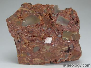
Sedimentary Rocks: These rocks are formed via the accumulation of sediment over time, typically with erosion as one of the major factors here. Sedimentary rocks can be broken down into three subcategories. These subcategories are clastic (formed by weathering), chemical (from dissolution) and organic (from the accumulation of plant or animal debris). Breccia is an example of a clastic sedimentary rock. The spaces between the largest fragments can be filled with a variety of different mineral materials. These help bind the rock together.


Sedimentary Rocks: These rocks are formed via the accumulation of sediment over time, typically with erosion as one of the major factors here. Sedimentary rocks can be broken down into three subcategories. These subcategories are clastic (formed by weathering), chemical (from dissolution) and organic (from the accumulation of plant or animal debris). Breccia is an example of a clastic sedimentary rock. The spaces between the largest fragments can be filled with a variety of different mineral materials. These help bind the rock together.
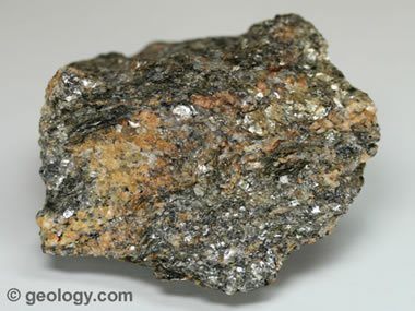
Metamorphic Rocks: These rocks have been formed and modified by heat, pressure, and chemical processes while buried deep below the Earth's surface (generally speaking). The two subcategories of metamorphic rocks are foliated (produced by heat exposure and pressure, with a layered or banded appearance) and non-foliated (no layered or banded appearance). One interesting example of a metamorphic rock is schist, which is foliated. It can contain large amounts of mica, which causes the rock to be split into thin pieces.
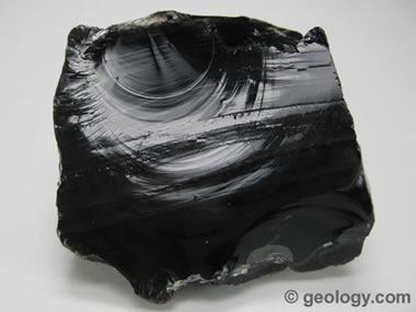
Igneous Rocks: These rocks are formed from the solidification of molten rocks as a result of extreme heat and then cooling. The two basic kinds of igneous rocks are intrusive, which solidify below the Earth's surface and extrusive, which form above the Earth's surface. Obsidian is my favorite kind of igneous rock due to its glossy appearance. It gets this appearance as a result of very rapid cooling to the point where crystals do not form.
Source for All: www.geology.com
There are also twelve soil orders in the world. These are:

Tuesday, March 4, 2014
Meet Gustav

Personal Photo
Please excuse the shot glasses
For an ongoing class lab, we are each growing our own sunflowers in cups. These sunflowers will ultimately be transplanted into a community garden near campus because they are thought to remove lead from the soil. Since our community garden is located in an urban area, it possibly contains lead as a result of many years of vehicle pollution.
I think Gustav (my sunflower) was a late bloomer and I thought I was going to have to get another seed. When I left for a debate trip on February 19th, he still had not sprouted and just looked like an empty cup. I came home to this after the trip!
I have been watering Gustav faithfully and leaving him where he can get some sunlight during the day. As of today, Gustav measures eighteen inches tall!
Wednesday, February 12, 2014
Windrose Plots
These windrose plots are from the four seasons of 1992 in Nashville, Tennessee. I was born in Nashville during this year.
Here is an aerial view of the Nashville International Airport:


Here is an aerial view of the Nashville International Airport:
Spring:
Summer:
Fall:
Winter:
From these graphs, we can see that seasons have a massive impact on the wind speed and direction. On August 27 of this year, three F0 tornadoes touched down in Middle Tennessee, which could have impacted the data in the summer section.
Monday, February 3, 2014
Solar Trajectory Lab

In this lab, I determined the trajectory of the sun by using an 8 inch stick, the length of its shadow, and the direction of the shadow cast.

Subscribe to:
Posts (Atom)